
Manitoba Eco-Network’s: Manigotagan River Canoe Map & Interactive Website
Manigotagan River Provincial Park is about 200 kilometers northeast of Winnipeg, beginning at the northwest edge of Nopiming Provincial Park and ending 100 kilometers downstream at the community of Manigotagan, on Lake Winnipeg. It has the distinction of being Manitoba’s youngest provincial park, having begun as a Park Reserve in 1997. Back then it was the subject of intense public education and campaigning by Manitoba's Western Canada Wilderness Committee, so in response the Manitoba government expanded the Park Reserve, establishing it as a provincial park in 2004. The communities of Manigotagan and Hollow Water First Nation both gave their consent for protection of the area because it was developed in a manner that respected their treaty rights and the goals and values of the communities, and their continued support is helping ensure the natural, cultural, and recreational heritage of the area is preserved.
Manigotagan River Provincial Park contains all the features of the Canadian Shield along the park corridor, which stretches 750 meters from each bank of the river. The landscape is diverseand spectacular, with sheer rock faces covered in Jack Pine and Lichen, stands of Balsam Poplar, Green Ash andElderberry, Prickly Pear Cactus, and the only Canada Yew found in Manitoba. Area wildlife includes moose, black bear, wolf, eagles, and woodland caribou. The park is composed of two land use categories, with 99 percent designated as backcountry use, forever protected from mining, logging and hydro-electric development. Archaeological surveys have revealed thousands of artifacts, indicating the area was used by Blackduck and Laurel cultures as far back as 2200 years. More recently the Manigotagan has been used by trappers, loggers, and miners, as rusting log boom anchor bolts, an occasional trappers cabin, and mining equipment scattered along portage routes attest.
In the summer of 2006, to mark the river’s status as a Provincial Park, six volunteers with the Manitoba Eco-Network embarked on several canoe trips to collect data and create a map of the 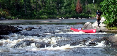 area. The team included a canoe guide from the area, two volunteers who documented its flora and fauna, one GIS mapping expert, the MEN project Coordinator, and Ron Thiessen from CPAWS. The groups goal was to gather enough information for the map and website so that visitors and people planning camping or canoeing trips in the area would know about safety and responsible use, as well as the natural and cultural history of the river and ecosystem. They hoped to inspire people to learn about and explore the area since it was so accessible and had a long human history, while increasing awareness of the rivers importance to all Manitobans since its clean waters nourish Lake Winnipeg.
Three years after the initial trips the Manigotagan River Canoe Map and interactive website became available online and in stores and libraries across Canada. Combined, the two resources are proving to be invaluable for education and orientation in the field and as a means of learning about one of Manitoba’s best whitewater rivers. The weatherproof, full-colour map is attractive, compact, and full of interesting information. It includes information on the history of the river, photos taken along the route, details on vegetation and wildlife, clearly marked rapids and campsites, points of interest, and tips for responsible camping practices. The digital interactive website provides more specific information about the rapids, along with tips to navigate them, in the form of downloadable pdf files and videos. Trip videographer and photographer, Ron Thiessen, notes that “we wanted to bring the place into peoples’ homes.”
At the official map release Anne Kirch, former GIS Manager at the Eco-Network and the leader of the Manigotagan Project, said “We believe this unique online map and trip planner is the first of its kind in the world. People can log on to the map from anywhere to get a taste of a trip on the river – complete with photos and videos, plus lots of information about the river environment, its heritage, and natural history.” The existence of these tools wouldn’t have been possible without the hard work of the six volunteers who endured the challenges of hiking and canoeing in Manitoba in the summer, with biting insects, rain, hot sun, forest fire threats, and low water levels.
While presenting MEN’s Manigotagan River Canoe Map and interactive GIS website at The Canadian River Heritage Conference in Ottawa last June, Brian Miller found that it was the only project of its kind. MEN’s display, “Manigotagan: A Digital Portrait of a Wild River”, received a great deal of interest and inspired a couple of groups to look into it in their own regions, and the interactive digital website proved unique in Canada (and the world) for the scope and depth of its content. The conference’s focus was to emphasize the importance of Canadian rivers to our culture, history, and environment, and the Manigotagan was the only Manitoba river represented. The pioneering work of the Manitoba Eco-Network’s GIS and Mapping Centre is turning a new generation of outdoor enthusiasts across Canada onto this river.
To use the interactive website or purchase paper copies of the Manigotagan River Canoe Map please visit this link:
www.mbeconetwork.org/canoemap
Images and text provided by Manitoba Eco-Network.